

-
About
History-Tradition
Geographical & Economic
Miscellaneous
-
Administration
Deputy Commissioner
DC Office
DDLG/ADC
About Sections
Important Information
-
Govt. Offices
Security & Discipline Affairs
Health
Education & Culture
Agriculture & Food
Land & Revenue
Human Resources
-
District Social Welfare Office
-
City Social Welfare Office, Narail
-
Department of Youth Development
-
District Co-operative Office
-
District Women Affairs Office
-
BRDB
-
District Polli Jibikayon Project Office
-
District Palli Daridro Bimicon Foundation Office
-
District Islamic Foundation Office
-
Sarkari Shishu Paribar(Boys), Narail
Engineering
-
Department of ICT,Narail
-
District Local Govt Engineering Office
-
District Public Health Engineering office
-
District Education Engineering Office
-
District Relief & Rehabilitation Office
-
District Palli Biddut Somitee Office
-
District Information Office
-
District Roads & Highways Office
-
District Public Works Department office
-
District Water Development Board Office
-
Narail Electric Supply Office, WZPDCL, Narail
-
District BTCL Office
-
District Electricity Development Board Office
-
District Social Welfare Office
-
Local Govt,
District Council
Municipality
Upazila Council
-
Other Institutions
Educational Institutions
Organizations
-
E-Services
National e-Services
District E-Service Centre
Union Digital Centre
-
Revenue Services
প্রদত্ত রাজস্ব সেবাসমূহ
List of Union Land Assistant Officers
-
Activities of District Administration
Services
- Gallery
- Smart Bangladesh
-
About
History-Tradition
Geographical & Economic
Miscellaneous
-
Administration
Deputy Commissioner
DC Office
DDLG/ADC
About Sections
Important Information
-
Govt. Offices
Security & Discipline Affairs
Health
Education & Culture
Agriculture & Food
Land & Revenue
Human Resources
- District Social Welfare Office
- City Social Welfare Office, Narail
- Department of Youth Development
- District Co-operative Office
- District Women Affairs Office
- BRDB
- District Polli Jibikayon Project Office
- District Palli Daridro Bimicon Foundation Office
- District Islamic Foundation Office
- Sarkari Shishu Paribar(Boys), Narail
Engineering
- Department of ICT,Narail
- District Local Govt Engineering Office
- District Public Health Engineering office
- District Education Engineering Office
- District Relief & Rehabilitation Office
- District Palli Biddut Somitee Office
- District Information Office
- District Roads & Highways Office
- District Public Works Department office
- District Water Development Board Office
- Narail Electric Supply Office, WZPDCL, Narail
- District BTCL Office
- District Electricity Development Board Office
-
Local Govt,
District Council
Municipality
Upazila Council
-
Other Institutions
Educational Institutions
Organizations
-
E-Services
National e-Services
District E-Service Centre
Union Digital Centre
-
Revenue Services
প্রদত্ত রাজস্ব সেবাসমূহ
nformation of Balubalmahal
Jalmahal information
List of Union Land Assistant Officers
-
Activities of District Administration
Services
-
Gallery
Photo Gallery
Video Gallery
-
Smart Bangladesh
ICT Master Plan
Vision 2041
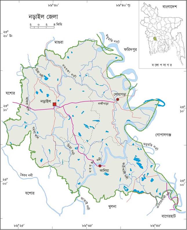
In the geographical location Narail District is located at 89.31 Longitude and 23.11 latitudes. Baghparpara upazila of Jessore district, Jessore sadar upazila and abhaynagar upazila on the west, salikha upazila and mohammadpur upazilas of Magura district on the north, alfadanga upazila of Faridpur district, Kashiani upazila and gopalganj sadar upazilas of Gopalganj district and Mollahat upazila of Bagerhat district, techhada upazila of Khulna district, Digholia upazila and phultala upazila and Jessore's Abhaynagar upazila. Land of Narail land slopes towards south. This geology can be divided into three regions. Upper latitude of the northwest, the lowlands on the middle of the Madhumati river in the north and east regions, and the middle-height region of the Nabaganga river and the Chitra river. [2] Pucca road of this district is 243 km, semi-width 74 km, Kacha road 1615 km and waterway 67 nautical miles. Traditional transport includes palanquin (extinct), horse carriage, buffalo cart, bullock cart (nearly extinct) and boat.


Planning and Implementation: Cabinet Division, A2I, BCC, DoICT and BASIS
Technical Assistance:
![]()
Developed By:
